
MAP OF THE MONTH – Trails of the American West
Armchair General has partnered with The Map as History, a company that produces outstanding animated maps with accompanying narration. Each month, a link to one of their animated maps will be featured on the ACG site.
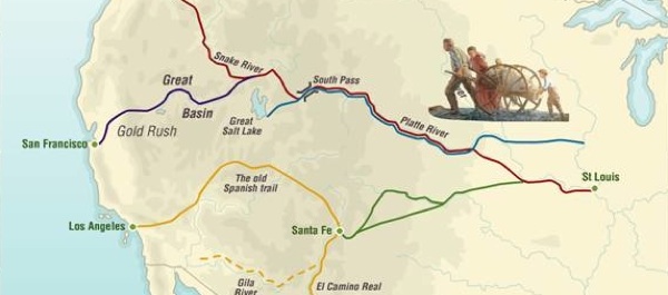
This month’s map explores the Trails of American Westward Expansion. In the days before railroads were built to link the Midwest with the Pacific Coast, a half-million settlers used these difficult, often dangerous overland routes to travel to Oregon, California, New Mexico, the Great Salt Lake and elsewhere in the wide-open lands of the American Western frontier.
{default}Click on the map above to view animation.
To learn more about the trails that took settlers westward in the days before railroads crossed the Rockies, click on the titles of online articles below.
Oregon Trail: Wagon Tracks West
Fort Laramie: Gateway to the Far West
Fort Laramie, Military Bastion of the High Plains book review
Actually, I’m very disappointed by this map – expected a LOT more detail, and expected it to show more trails and cutoffs. Where is, for example, the Bozeman Trail? the Cheyenne-Deadwood Trail? the Sidney-Black Hills Trail? the Bismark-Deadwood Trail? the Whoop Up Trail? The Old North Trail? the Mullen Road? The Overland Trail? This is VERY disappointing.
I agree totally with Nathan. I live on the Bismarck-Deadwood trail and have searched for years for more info on locations of Stage Stations, trading posts etc. There is nothing that I can find.